Clarendon Jamaica
Population: 211,447 (1991)
Capital: May Pen
Major Towns: Race Course, Frankfield, Porus, Lionel Town, Thompson Town, and Alley
Clarendon Parish Overview
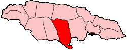
Location
Clarendon Parish is situated near the center of Jamaica, on the island’s southern coast, roughly equidistant from the eastern and western extremities. Part of Middlesex County, it shares borders with Manchester to the west, Saint Catherine to the east, and Saint Ann to the north. May Pen serves as the parish’s capital.
History
Named in honor of Sir Edward Hyde, Earl of Clarendon, this parish was formed by merging three smaller parishes: St. Dorothy's, Vere, and the original Clarendon. Before the merger, Chapelton acted as the capital. Over time, Clarendon has grown into one of Jamaica’s vital regions, reflecting its rich heritage and cultural significance.
Geography
Spanning an area of 1,196 square kilometers, Clarendon is the third-largest parish in Jamaica. It is mostly characterized by flat plains, intersected by several rivers, with the Rio Minho running the entire length. In the north lie the Mocho Mountains (approximately 200 feet high) and the Bull Head Mountain range (reaching 2,800 feet), reputed to be near the geographical center of the island. The Vere Plain is another notable landscape feature.
Portland Point, Jamaica’s southernmost tip, extends from Clarendon’s southern shoreline and features Jackson Bay Beach, the Portland Cottage community, and two locations referred to as Rocky Point - one primarily residential and the other functioning as a port for alumina exports.
Major Industries and Employment
- Bauxite Mining: As the source of Jamaica’s primary mineral resource, bauxite, Clarendon hosts significant mining operations managed by Jamalco and Alcoa.
- Agriculture: The parish is a key agricultural hub, producing tobacco, cotton, pimento, ginger, bananas, coffee, and cocoa. May Pen is especially notable for its citrus packing, focusing on the famed ‘Trout Hall’ oranges. Dairy and fish farming, copper mining, and sugar-cane production also play important roles.
- The Denbigh Agricultural Showground, near May Pen, is a prominent venue for major agricultural events and showcases.
Cultural, Historical, and Recreational Sites
- St. Peter’s Church (Alley): Dating back to 1671, this is among Jamaica’s oldest churches. Its current structure, built around 1715, features a distinctive brick-and-mortar design with a prominent tower.
- Portland Point Lighthouse: Standing at 145 feet, it is the tallest lighthouse in Jamaica. Located on Portland Ridge at the island’s southernmost edge, it emits a white flash every 15 seconds.
- Halse Hall Great House: Originally granted to Major Thomas Halse in 1655, the property evolved into a two-storey estate by the late 1740s. Its architectural highlights include grand stone steps and a peaked portico, with additional construction that complements the original design.
- Milk River Spa: Famed for its highly radioactive mineral waters, said to be beneficial for various ailments. Located about 10 miles south of May Pen, the spa remains a popular therapeutic destination.
- Suttons Railway Station: An example of Jamaica/Georgian architecture, the timber station is perched on a stone base and showcases intricate latticework along its handrails, with a cantilevered zinc roof.
- Four Paths Railway Station: Constructed in the early 1900s, this two-storey concrete building features a blend of aluminum louvers and sash windows, with the station master’s living quarters on the upper floor.
- Claude McKay’s Birthplace: The celebrated Jamaican writer and poet was born in James Hill, Clarendon, in 1889. Recognized internationally for his contributions during the Harlem Renaissance, his influence endures in Jamaican culture and beyond.
- May Pen Clock Tower: Erected in stone and about 24 feet tall, it commemorates Jamaica’s contributions to World War I, with an inscription honoring the sacrifices of Jamaican servicemen.
Clarendon’s diverse landscapes, thriving agriculture, and historic landmarks make it both culturally and economically significant. Visitors and residents alike can appreciate its natural beauty, rich heritage, and abundant opportunities for exploration.